A humanitarian satellite expands data access across the entire decision chain, from frontline practitioners to global policymakers, and critically, to communities themselves. The impact of a humanitarian satellite unfolds across multiple levels, from immediate operational gains to long-term system transformation. At the front lines, it enables faster, more precise decision-making that improves response, targeting, and coordination. Over time, these gains compound across projects, programs, sectors, and regions, strengthening shared intelligence, reducing inefficiencies, and reshaping how information flows through humanitarian and development systems.

The
Details
Impact Area | Where We Image | Who It Covers | Collection Requirement |
|---|---|---|---|
Resilient Cities | Global urban footprints (~4.06M sq km) | ~4B people, including ~1B in informal settlements | ~10% capacity - Annual global pass + selective re-imaging of high-risk cities |
Safety from Conflict | Conflict zones, refugee/IDP camps (~15,000 sq km), displacement corridors | ~2B in fragile/conflict settings, 108M displaced | ~20% capacity ? High-frequency revisit over active zones + corridor monitoring |
Human Rights & Accountability | Mass graves, detention sites, villages, protests, elections | >4B in rights-constrained environments | ~7% capacity - Tasking with repeat verification, high overlap with conflict |
Protecting Indigenous Lands | Indigenous territories (~38M sq km), boundary hotspots | ~476M Indigenous Peoples | ~5% capacity - Periodic monitoring of high-risk encroachment zones |
Early Warning & Disaster Response | Floodplains, wildfire zones, coastal hazards | ~90M+ affected annually by disasters | ~18% capacity - Event-driven surge + pre/post disaster baselines, recovery |
Resilient Island Communities | SIDS (24,111 sq km) + coastal zones & EEZ hotspots | ~65M people | ~4% capacity - Coastal + land monitoring; overlap with disasters |
Ending Human Trafficking | Brick kilns, AIS-dark vessels, case-specific sites | ~27.6M people in forced labor | ~3% capacity - Investigative tasking, pattern detection over time |
Food Security & Agriculture | Smallholder farmland (~25M sq km) | ~500M farmers | ~15% capacity - Seasonal imaging aligned to crop cycles (not constant coverage) |
Poverty Alleviation | Urban, rural, and climate/conflict-affected zones | ~700M extreme poverty; billions more vulnerable | Integrated across all above |
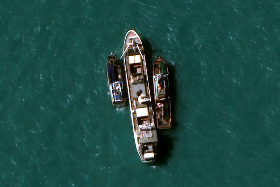
Invisible Slave Ships
In 2015, an investigation led by the Associated Press exposed a vast human trafficking network operating across Southeast Asia’s fishing industry, where thousands of men were held in slavery at sea. Many had been trafficked or coerced onto vessels and were forced to work under brutal conditions, often for years without setting foot on land. These ships operated far from shore, beyond the reach of traditional oversight, making both detection and intervention extraordinarily difficult.
Satellite imagery became a turning point. High-resolution imagery from DigitalGlobe helped investigators and authorities locate vessels linked to the trafficking network, providing visual evidence of their position and activity in remote waters. With this information, authorities were able to intercept fishing boats, leading to the rescue of enslaved individuals and the disruption of the broader system. The investigation ultimately freed more than 2,000 people. It stands as a powerful example of what becomes possible when visibility reaches places that were previously hidden, and how access to timely, high-quality imagery can directly contribute to life-saving action and accountability.

Disaster Resilience
MapAction, a humanitarian organization specializing in geospatial support, uses high-resolution satellite imagery to provide real-time mapping during emergencies, helping responders understand rapidly changing situations when on-the-ground information is scarce or fragmented. In the immediate aftermath of disasters such as earthquakes, floods, and hurricanes, MapAction integrates satellite imagery with other data sources to produce operational maps that show damaged infrastructure, flooded areas, population concentrations, and accessible routes. These maps become a shared reference point for humanitarian actors, enabling faster coordination, more targeted aid delivery, and better-informed decision-making in the first critical hours and days of a response.
High-resolution imagery is particularly valuable when access is limited, or conditions are too dangerous for field teams. MapAction analysts can remotely assess damage, identify cut-off communities, and support logistics planning without waiting for ground surveys. During major responses, such as earthquakes or large-scale flooding events, this capability helps humanitarian organizations prioritize where to send teams, how to route supplies, and where needs are greatest.
Community-Driven Crisis Mapping
For the Humanitarian OpenStreetMap Team (HOTOSM), access to high-resolution satellite imagery is a force multiplier for one of the world’s most powerful community mapping movements. HOT has mobilized over 1 million volunteer mappers globally, generating billions of map edits that have supported tens of millions of people across disaster response, public health, conflict monitoring, and resilience efforts. Satellite imagery provides the broad, scalable foundation for this work, enabling rapid mapping of roads, buildings, and infrastructure across entire regions, while drone imagery adds ultra-high-resolution detail for dense or rapidly changing areas. Together, they create a complementary stack, wide-area visibility from space paired with ground-level precision, that allows local communities and global volunteers alike to produce actionable, up-to-date maps where none existed before. The result is not just better data, but faster response, stronger local ownership, and a living map of the world that is continuously improved by the people who use it most.


A Witness for Restoration
High-resolution, open-access imagery would enable BRCiS to move from fragmented, site-based monitoring to continuous, landscape-scale visibility across its resilience and restoration programs. With routine, repeatable imaging, teams could track vegetation recovery, water access, land use change, and climate impacts in near real time, building a dynamic picture of how interventions are performing and where support is needed most. This would significantly lower the cost and operational burden of monitoring while improving consistency and comparability across regions. Just as importantly, it would create a reliable, rapidly updating environmental evidence base that strengthens adaptive management, supports donor accountability, and empowers local partners with timely insights to guide decision-making on the ground.