Fighting Fire with Data: A Case Study on Earth Fire Alliance and FireSat setting a trend towards non-profit Remote Sensing
- Bill Greer
- May 22, 2025
- 6 min read

Executive Summary: FireSat and the Future of Purpose-Built Satellites
FireSat is the first global satellite constellation purpose-built for wildfire detection and monitoring. Developed in close collaboration with the wildfire community, its design prioritizes fast, actionable, and openly licensed data. With a planned constellation of 50+ multispectral satellites capable of revisiting every point on Earth every 20 minutes or less, FireSat aims to deliver data in near real-time to end users such as first responders, incident commanders, and fire scientists.
Unlike traditional satellite ventures, FireSat was created via a public-private-philanthropic partnership, removing commercial business constraints while still leveraging the speed of technological execution for public benefit, operational utility, and open access. The mission was shaped not around available technology, but around clearly defined user needs.
FireSat is the flagship mission of Earth Fire Alliance, a non-profit coalition with a mission to deliver transformative real-time data from all wildfires on Earth.
What Is Earth Fire Alliance & FireSat?
Earth Fire Alliance spent time upfront having conversations with fire managers and practitioners in the field to ensure the satellite constellation will meet gaps in existing wildfire data and deliver exactly what’s being asked for by the community. Hundreds of conversations later, there was a clear and expressed need for more comprehensive data on all stages of the fire lifecycle and more frequent, timely, and reliable updates delivered directly in the field to inform real-time decisions. With global megafires becoming more frequent, burning hotter, spreading faster, and threatening an increasing number of communities, the technology must provide data around the clock and around the world. But more was being asked than better tools to put out every fire. There is an unmet need for real-time data to characterize active fire intensity and understand changes in this new fire paradigm. Better data from a system built by and for the wildfire community will inform new fire management strategies that make the best use of limited resources, while supporting beneficial fire practices, proactive stewardship, and resilience and adaptation strategies.
The FireSat design, with low latency and persistent global coverage, is specifically intended to deliver the right data to the right people, at the speed of the end users’ needs. From concept to execution, the alignment between mission, technology, and partners should be the industry standard. Credit goes to Earth Fire Alliance founding partners Muon Space, Google Research, Google.org, the Gordon and Betty Moore Foundation, and the Environmental Defense Fund (EDF) for developing a blueprint worth following.
The Market Failure in Wildfire Monitoring and the Satellite Industry
National satellite systems like MODIS and VIIRS do exist for wildfire monitoring, and they offer scientifically precise global data, but they fall short for operational use. The resolution is too coarse, revisit times are too slow, and access is too limited for the fast, actionable data frontline responders need for decision-making around active wildfires. Data must be delivered in cadence with their mission. Commercial satellites typically don’t have the revisit at the proper time of day for operational use, which is why the wildfire community has traditionally relied on aerial or drone data. Commercial thermal sensors are out there too, but they're often locked behind paywalls or prioritized for defense and intelligence customers, making them unreliable for consistent, real-time wildfire response. This is an example of a pattern of market failures across other domain-specific needs as well. Where the public data sources fail, typically on resolution and revisit, commercial markets are intended to come in and fill those gaps. The commercial satellite market, however, cannot remain committed to an individual mission, leaving a market failure and a public goods gap to be resolved with new business and access models.
FireSat Roadmap
One of FireSat’s most impressive achievements is its rapid development, going from concept to launch in three years, a pace rarely seen in commercial or scientific missions. The value of speed to execution is particularly interesting both to cost savings and in achieving impact when the needs are urgent. Below is the FireSat timeline,
2022: Feasibility Study: FireSat began with an Environmental Defense Fund-led feasibility study to define user needs (e.g., revisit rate, resolution, workflows), and to establish mission justification and practicality. The user-centered study resulted in defined global user groups, user requirements, a theory of change, project goals, gap analysis for current and planned fire technologies, and initial recommendations for a philanthropically driven space-based fire monitoring and characterization system - FireSat.
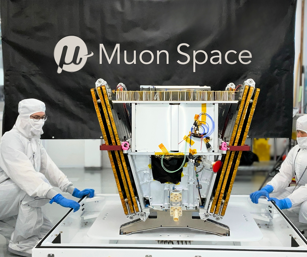
2023: Mission Formulation: With validated user needs, the team defined technical requirements: sensor design, orbit selection, data volumes, costs, and CONOPs. Muon Space played a key role in aligning mission goals with hardware from the start, favoring performance of the overall constellation while keeping costs manageable, and working directly alongside other partners to reduce the mission risk and increase the mission value. Focus on the mission from the start led to some very impressive and innovative hardware designs, reducing false positives and improving each satellite’s capacity to meet the needs of end users.
2024: Nonprofit Launch & System Build: Earth Fire Alliance was established as the nonprofit home of FireSat, and subsequently introduced an Early Adopter Program to ensure end users are engaged and ready to act upon the first operational data anticipated in 2026. Muon completed the first protoflight satellite and instrument build in 2024, prepping for a 2025 launch. FireSat emphasizes usability and simplicity, ensuring low-friction, interoperable, and actionable data delivery for fire managers, which is often an afterthought to a satellite's core mission.
2025: Launch & Lessons: The FireSat protoflight launched in March aboard SpaceX’s Transporter-13 rideshare mission. The on-orbit demonstration will validate the performance of the FireSat system architecture, and Protoflight data products will enable the Alliance to finalize distribution processes for operational FireSat data, with the goal of seamless integration into as many existing end-user applications as possible.
2026 & Beyond: Collaboration Earth Fire Alliance plans to launch the first three operational satellites in the FireSat Constellation in Summer 2026, and is also looking beyond to launch the full constellation and provide the global revisit needed for the system to be fully effective for wildfire management. Building the capacity of the constellation will remain a considerable effort as well as data distribution, user adoption, and the necessary global impact.
FireSat Coopetition:
The future will bring an even more interesting landscape of collaboration and competition. Costs and timelines (as shown above) are coming down, and new business models are emerging. The emergence of WildFireSat, a joint project from the Canadian Government (including the Canadian Space Agency, Natural Resources Canada, Environment & Climate Change Canada) and Spire and OroraTech, shows that mission-focused private-public interest in this space is also growing. FireSat’s open model creates a rising tide for all players: commercial, civil government, and non-profit. If WildFireSat can differentiate while leveraging open data, the entire wildfire ecosystem benefits. More data meeting the needs of end users will only help the global cause. New business models and their interactions with legacy space business models are going to dictate the priorities in the industry for the future. Systemic cooperation between commercial industry, government, non-profits, and NGOs is needed to create a thriving market that also serves the needs of the people these satellites were initially designed to support.
Firesat is one example of how satellites can better support people in crisis. However, there still remain many more people and communities in crisis where space-based technology can and should help as a foundational tool.
Common Space’s Role and Challenges
Common Space is championing an independent, high-resolution satellite to support the most pressing human needs. Outside of government control, such a satellite mission could be directed to cover the communities that need it most, unbiased by political agenda or commercial value.
These affected communities represent the world's most vulnerable - the slum-dwellers, the survivors of human rights abuses, the indigenous tribes, the displaced, and the impoverished.

No satellite system can do everything. Teaming up and building a non-profit coalition of independently run, but mutually beneficial systems to improve civil society should be a part of our mutual long-term vision for the best possible future.
How Can You Support the Mission?
We’re witnessing a pivotal shift in Earth observation. Purpose-built, mission-driven, non-profit satellite systems are emerging as a powerful counterbalance to commercial and defense priorities. The Future is here, but it’s not set. We need your support to make it happen, and bring in a new aspirational class of missions to help save lives and mitigate the worst of the human cost of the complex combinations of climate and conflict crises.
The future of space isn’t just private or government-led. These incredible assets should serve people and address our most pressing needs. The future of space is cooperative and open.
Join us as we build a new wave of satellite technology for the people, by the people. Learn more at the Common Space website.
Common Space is currently seeking funding for our own feasibility study. You can access our concept notes for our feasibility study here or on our website.
Earth Fire Alliance is currently seeking coalition partners and Early Adopters. You can learn more and get involved here.


Comments